Έκρηξη του
ηφαίστειου Παβλόφ στις 18 Μαΐου, φωτογραφία από αστροναύτη του Δ.Δ.Σ. Pavlof
volcano in the Aleutian arc erupts May 18 in this image captured by astronauts
on the International Space Station.
Οι
δορυφόροι σε τροχιά γύρω από τη γη και από τους αστροναύτες του Διεθνή
Διαστημικού Σταθμού τράβηξαν και φέτος υπέροχες φωτογραφίες του πλανήτη. Η NASA επέλεξε τις καλύτερες για το 2013. Μεταξύ αυτών βλέπουμε
φωτογραφίες από εκρήξεις ηφαιστείων, τυφώνες και απομακρυσμένες περιοχές της
γης.
Ο
τυφώνας Χαγίαν μια μέρα πριν πλήξει τις Φιλιππίνες. Η φωτογραφία τραβήχτηκε από
το δορυφόρο Aqua
της NASA. Terrifying
beauty: Supertyphoon Haiyan the day before it made landfall in the Philippines.
The coast of the Philippines can be seen outlined on the far left of the image.
Captured Nov 7 by NASA's Aqua satellite.
Αστροναύτης
του Δ.Δ.Σ φωτογραφίζει την έκρηξη του ηφαιστείου Σακαραζίμα στην Ιαπωνία. Amazing:
An astronaut on the International Space Station took this photo on Jan. 10 of
an eruption on Sakurajima, one of Japan's most active volcanoes.
Φωτογραφία
από το δορυφόρο Terra
της NASA. Ο
ανεμοστρόβιλος που έπληξε την Οκλαχόμα στις 20 Μαΐου του 2013 και είχε
αποτέλεσμα το θάνατο 24 ανθρώπων και ζημιές ύψους 2 δισ. Δολαρίων. Devastating:
Running left to right through the center of this image is the scar from the
EF-5 tornado that ran through Moore, Oklahoma on May 20, 2013 killing at least
24, injuring 377 and likely topping $2 billion in damages. Captured June 2 by
NASA's Terra satellite.
Η
Αλάσκα μια από τις σπάνιε φορές που δεν υπάρχουν σύννεφα. Φωτογραφία του
δορυφόρου Terra
της NASA στης 17 Ιουνίου. The
frozen tundra: Alaska is almost always mostly, or at least partially, covered
with clouds, but this rare, cloudless moment was captured June 17 by NASA's
Terra satellite.
Σύννεφα
προσεγγίζουν τις ακτές της Καλιφόρνια. Φωτογραφία του δορυφόρου Terra της NASA στης 14 Απριλίου. California
dreaming: This image of clouds off the California coast was captured Apr. 14 by
NASA's Terra satellite.
Η
πόλη Ρέμο στην έρημο της Νεβάδα. Φωτογραφία από αστροναύτη του Δ.Δ.Σ. The
world's biggest little city: This image of Reno, Nevada at night was captured
Jan 28 by an astronaut on the International Space Station.
Σύννεφα
πάνω από νησάκι Isla
Socorro στον Ειρηνικό
Ωκεανό, στις 22 Μαΐου. Φωτογραφία από τον δορυφόρο Aqua της NASA. Live art: Isla Socorro creates von
Karman vortices in the clouds above the Pacific ocean May 22 in this image
captured by NASA¿s Aqua satellite.
Λίμνη
Μίσιγκαν στις 24 Μαΐου από το δορυφόρο NASA / USGS Landsat 8. Great lake: A
cluster of small images in the far northern reaches of Lake Michigan in a photo
captured May 24 by the NASA/USGS Landsat 8 satellite.
Αμμόλοφοι στην
Αυστραλία. Φωτογραφία από την 25η Μαρτίου στο Δ.Δ.Σ. This image sand dunes in
Australia's Great Sandy Desert was taken March 25 by an astronaut on the
International Space Station.
Φωτογραφία
του κόλπου της Πριγκίπισσας Σαρλοτ στην Αυστραλία. Φωτογραφία από την 20η
Απριλίου από τον δορυφόρο NASA/USGS Landsat 8. This image of
Princess Charlotte Bay in Australia was captured April 20 by the NASA/USGS
satellite Landsat 8.
Φωτογραφία
του Αμαζονίου στις 28 Αυγούστου από το δορυφόρο NASA/USGS Landsat 8. Disappointing: The
Landsat 8 satellite, launched by NASA and operated by the USGS, spotted new
deforestation (brown rectangles center right) in the Peruvian Amazon on Aug. 28
after American scientists received a tip from colleagues in South America.
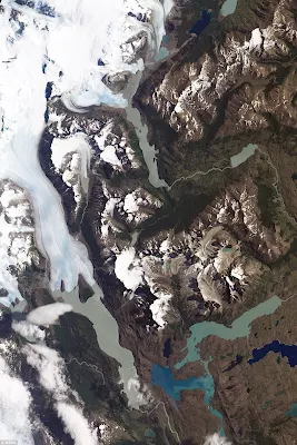
Το
Εθνικό πάρκο Torres
del Paine στην Χιλή. Φωτογραφία στις 21 Ιουνίου από
τον δορυφόρο 1 (EO-1).
Awe-inspiring: The Torres del Paine National Park, in Chilean Patagonia,
as captured Jan. 21 by NASA’s Earth Observing-1 (EO-1) satellite.
NASA highlights its
accomplishments in air and space for 2013. Release Date: 24 December 2013. Credit:
NASA


Δεν υπάρχουν σχόλια:
Δημοσίευση σχολίου