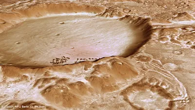
Χιονισμένος
κρατήρας στην οροσειρά στην οροσειρά Charitum Montes. Το “χιόνι” είναι εποχικό
φαινόμενο και πρόκειται για ξηρό πάγο, δηλαδή παγωμένο διοξείδιο του άνθρακα. This
computer-generated perspective view of Charitum Montes was created using data
obtained from the High-Resolution Stereo Camera (HRSC) on ESA’s Mars Express.
Centred at around 53°S and 334°E, the image has a ground resolution of about 20
m per pixel. The image shows the large breach in the northern wall of the
crater, located near to the uppermost sand dune. The dusting of carbon dioxide
ice is a seasonal feature in this region, which covers the crater floor and the
surrounding plains. Credits: ESA/DLR/FU
Berlin (G. Neukum)
H
κάμερα υψηλής ανάλυσης του διαστημικού σκάφους Mars Express της ESA (Ευρωπαϊκός
Οργανισμός Διαστήματος) που βρίσκεται σε τροχιά γύρω από το Άρη, φωτογράφησε
στις 18 Ιουνίου την περιοχή Charitum Montes μια περιοχή του Κόκκινου Πλανήτη,
κοντά στον κρατήρα Gale (τον οποίο εξερευνά το διαστημικό ρόβερ της ΝΑSA
Curiosiy).
This colour-coded
overhead view is based on an ESA Mars Express HRSC digital terrain model of the
region, from which the topography of the landscape can be derived. The colour
coding shows the very edge of the Charitum Montes mountain region at the top of
the image, with the highest elevation, while the subtle pedestal craters that
dot the image almost fade away with just a small amount of relief difference
between the elevated ejecta and the surrounding area. Centred at around 53°S
and 334°E, the image has a ground resolution of about 20 m per pixel. The image
was taken during revolution 10778 on 18 June 2012. Credits: ESA/DLR/FU Berlin
(G. Neukum)
Η
περιοχή Charitum Montes είναι μια οροσειρά με μήκος σχεδόν 1000 χιλιόμετρα,
είναι ορατή με τηλεσκόπιο από τη Γη, και εντοπίστηκε για πρώτη φορά το 1929 από
τον Έλληνα αστρονόμο Ευγένιο Αντωνιάδη (1870 – 1944).
Charitum Montes
imaged during revolution 10778 on 18 June 2012 by ESA’s Mars Express using the
High-Resolution Stereo Camera (HRSC). Data from HRSC’s nadir channel and one
stereo channel have been combined to produce this anaglyph 3D image that can be
viewed using stereoscopic glasses with red–green or red–blue filters. Centred
at around 53°S and 334°E, the image has a ground resolution of about 20 m per
pixel. Credits: ESA/DLR/FU Berlin (G.
Neukum)
Οι
εικόνες δείχνουν μεγάλους κρατήρες που περιέχουν παγωμένο διοξείδιο του
άνθρακα. Το διοξείδιο του άνθρακα υπάρχει στην ατμόσφαιρα του Άρη σε ποσοστό
96% και ανάλογα με τις εποχικές συνθήκες
που επικρατούν σε ορισμένες περιοχές του κόκκινου πλανήτη μπορεί να μετατραπεί
σε ξηρό πάγο.


Δεν υπάρχουν σχόλια:
Δημοσίευση σχολίου